Te Auaunga (Oakley Creek)
Te Auaunga was restored so it can be treasured and respected by future generations.
Introduction
Te Auaunga (also known as Oakley Creek) means swirling waters. It is the longest awa in the Tāmaki Makaurau / Auckland isthmus and flows between:
- Te Tātua a Riukiuta and Pukewīwī / Puketāpapa in the south to
- Te Waitematā, near Mōtū Manawa-Pollen Island Marine Reserve in the northwest.
Te Auaunga is a site of great cultural significance to mana whenua who have long-standing historical connections to the awa.
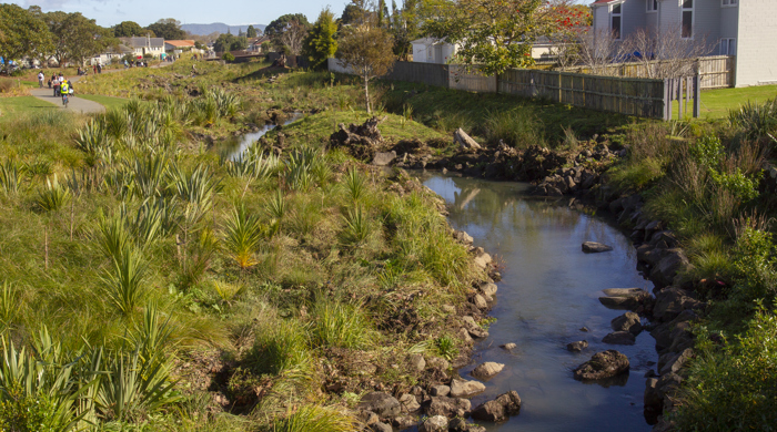
In pre-European times Te Auaunga was part of a vibrant ecosystem including wetlands, native trees and forests. It provided a rich habitat for kererū, tūī, ruru, tuna and other wildlife.
Major works took place from 2016 to 2019 between Sandringham and Richardson roads through to Walmsley and Underwood parks. These works helped restore the mauri of the awa. They used mātauranga and contemporary environmentally sustainable practices.
Mana whenua and the community wanted to return Te Auaunga to a healthy state within one generation. By then, native forest will shade the awa and it will support abundant wildlife. It will be a place for future generations to treasure.

Background
During the 1840s, the Crown took land in Te Tātua a Riukiuta and Pukewīwī / Puketāpapa from mana whenua and sold it to settlers. They removed remaining native forests and diverted water from Te Auaunga for livestock farming. Large scale quarrying of Te Tātua-o-Riukiuta provided a major source of aggregate materials that contributed to colonial expansion across the isthmus.
In the 1920s, settlers drained Te Wai-a-Rakataura to create land for large scale housing developments. In the 1930s they channeled the awa into a 1.3 km culvert to address flooding. However, this led to more flooding that put over 100 homes and residents’ lives at risk. Over time Te Auaunga became polluted and its mauri became degraded and diminished. The flow-on effect impacted the Waitematā Harbour, especially Mōtū Manawa-Pollen Island Marine Reserve.
Auckland Council and mana whenua in partnership
Te Auaunga project was originally intended as a stormwater engineering solution to increase capacity and reduce flooding in the area. This needed significant funding. Auckland Council chose to manage the project to ensure environmental, and better social and community outcomes.
The three local boards through which Te Auaunga flows supported the project.
Protecting the natural environment remains one of the most important responsibilities of mana whenua as kaitiaki. This is reflected in the design of the tohu. The double koru represents the coming together, around a common purpose and interest - to protect Te Auaunga.
The following iwi mana whenua participated and contributed:
- Ngāi Tai ki Tāmaki
- Ngāti Te Ata Waiohua
- Ngāti Tamaoho
- Ngaati Whanaunga
- Ngāti Whātua o Ōrākei
- Te Ākitai Waiohua
- Te Kawerau A Maki
They also shaped the project in a number of ways:
- Gifted the project name.
- Shifted the project from an artificial engineered response to a softer design. This allowed the stream to return to its natural state.
- Advocated for additional significant water quality management design features, like:
- devices that filter out rubbish
- better management of overland water flow
- vegetated swales
- improved fish passage and protection
- riparian planting.
- Supported the addition of a māra hūpara.
- Encouraged the inclusion of interpretive signage throughout the park.
- Identified the appropriate native plant species for replanting.
- Supported Te Whangai Trust to establish an on-site native plant nursery.
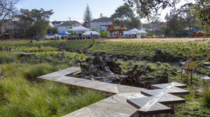
Outcomes and benefits
What started as a project to stop flooding became an exemplar for environmental and social outcomes through council, mana whenua and community working together.
Many awards in Aotearoa and overseas recognised this project. This lead to council and iwi mana whenua partnering on other projects.
To find out more and/or experience Te Auaunga:
- Read the Te Tohu o Te Auaunga Implentation Strategy (2019) to get a sense of the size and breadth of the project.
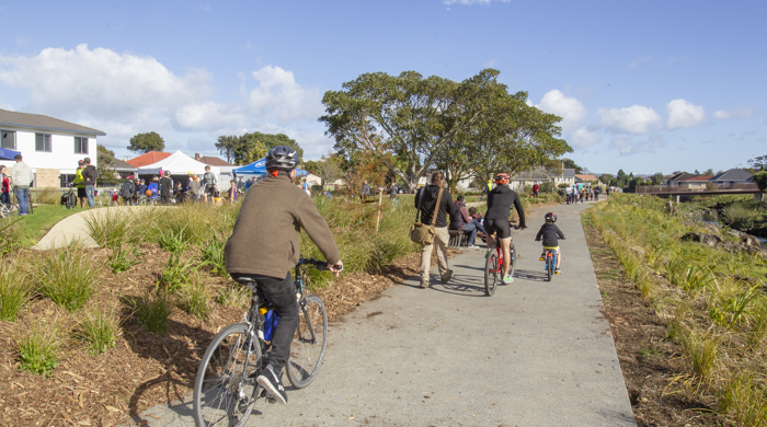
- Walk or cycle Te Auaunga - Wesley Path to experience the results of this project.